Space News & Blog Articles
NOAA reveals first images from new weather satellite
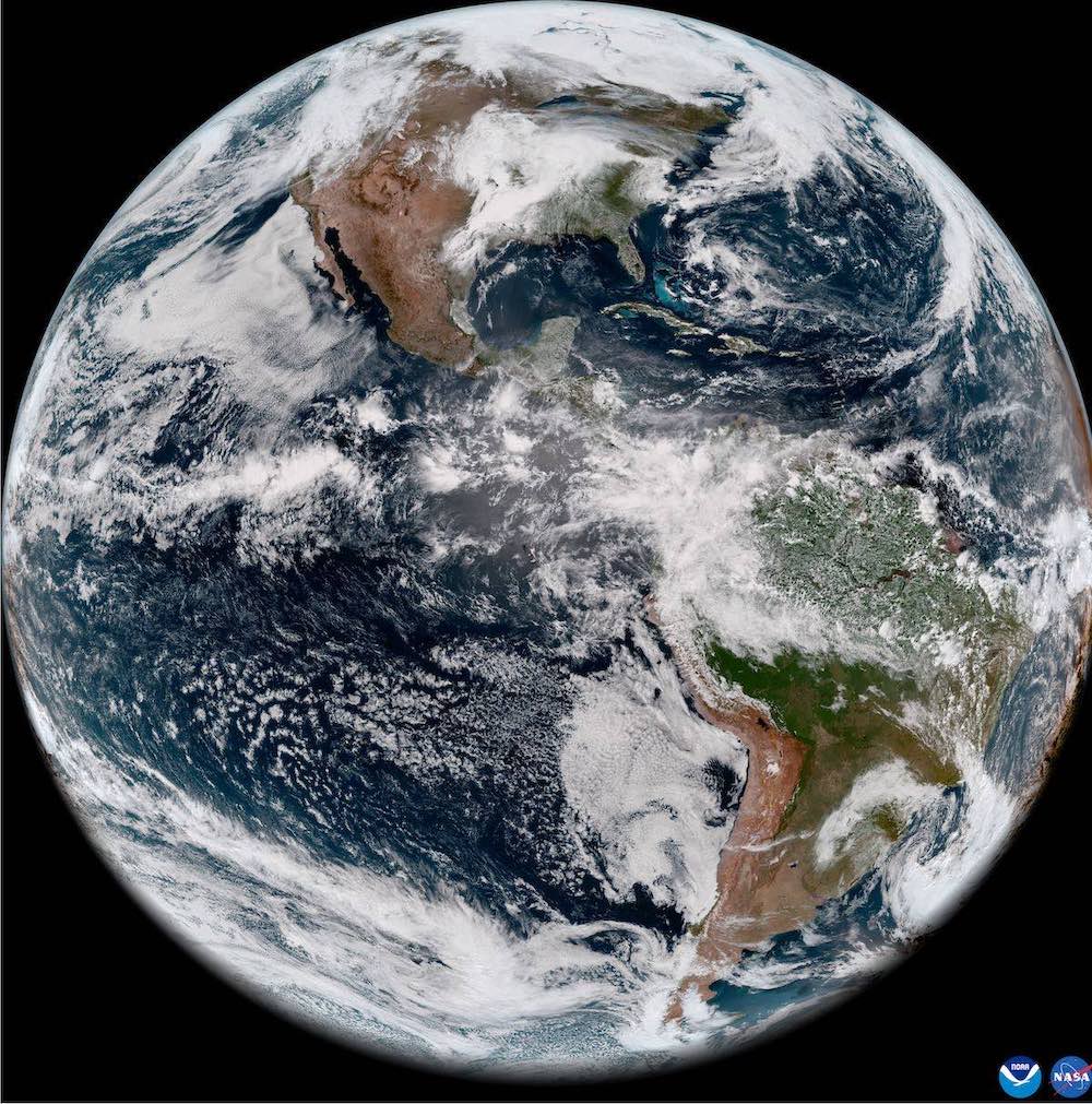
 GOES-18 full disk GeoColor image from May 5, 2022. This type of imagery combines data from multiple ABI channels to approximate what the human eye would see from space. Credit: NOAA
NOAA released the first imagery from the new GOES-18 weather satellite that launched March 1 from Cape Canaveral, and confirmed the spacecraft’s main camera doesn’t suffer the same cooling system problem that caused degraded vision in an earlier satellite.
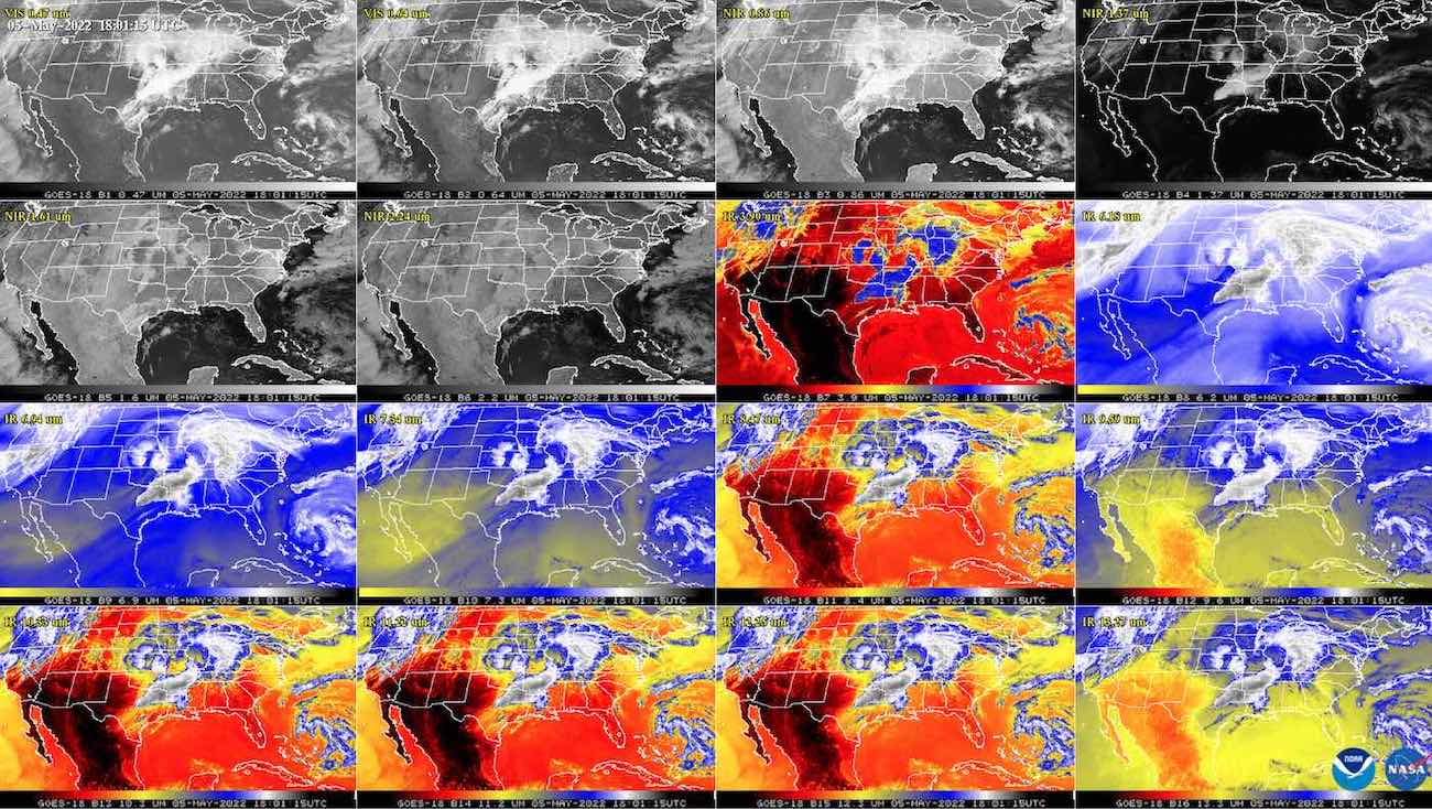
The first images from GOES-18 were captured May 5 from a position in geostationary orbit more than 22,000 miles (nearly 36,000 kilometers) over the equator. GOES 18’s primary camera, called the Advanced Baseline Imager, recorded the views in 16 channels, each tuned to see clouds, dust, smoke, and water vapor in different wavelengths of light.
The images released Thursday showed strong thunderstorms over northeast Texas, dry conditions over much of Mexico and the American Southwest, and fog near the coasts of California and Chile.
The new satellite is not yet operational, but is scheduled to take over real-time weather coverage of the western United States, Alaska, Hawaii, and the Pacific Ocean region in early 2023. It will replace GOES-17 in the so-called “GOES-West” position.
GOES-17’s camera instrument suffers from degraded performance, most likely caused by debris lodged in the instrument’s cooling system. The malfunction means the instrument’s detectors are unable to stay at the proper temperatures at certain times, leading to intermittent loss of some infrared imagery.
Ground teams were able to recover some of the instrument’s lost function. NOAA officials said earlier this year the GOES-17 imager is collecting about 97% of its planned data, with most image problems confined to times when the satellite is exposed to specific thermal conditions.
NOAA says GOES-18’s camera, built by L3Harris, is working as designed.
“The ABI cooling system is performing well, with no signs of the issue that affects its sister satellite, GOES-17,” NOAA said Thursday. “The ABI was redesigned for GOES-18 to reduce the likelihood of future cooling system anomalies. The new design uses a simpler hardware configuration that eliminates the filters that are susceptible to debris. ”
GOES-18, previously known as GOES-T, lifted off from Cape Canaveral on a United Launch Alliance Atlas 5 rocket. The Atlas 5 deployed the spacecraft, built by Lockheed Martin, into an on-target transfer orbit, then the satellite used its own propulsion to reach a circular geostationary orbit March 14.
At that altitude, satellites orbit Earth at the same rate of the planet’s rotation, meaning weather satellites can provide continuous views of the same hemisphere. NOAA renamed GOES-T as GOES-18 once it reached geostationary orbit.
Ground controllers maneuvered the satellite to a test location along the equator at 89.5 degrees west longitude, where GOES-18 took its first pictures for public release. The next step for GOES-18 will be a drift to 136.8 degrees west longitude for additional testing and instrument calibrations alongside GOES-17. In early 2023, NOAA plans to transition to GOES-18 as the operational satellite at the GOES-West location, and GOES-17 will become a backup in the U.S. government’s weather satellite fleet.
NOAA has also released the first observations by GOES-18’s magnetometer instrument and space environment sensor suite, allowing the satellite to monitor solar activity and space weather, helping provide early warnings for events that could disrupt communications, power grids, navigation systems, and spacecraft operations.
 This GOES-18 image shows the contiguous United States observed by each of the ABI’s 16 channels on May 5, 2022. This 16-panel image shows the ABI’s two visible, four near-infrared and 10 infrared channels. The visible and near-IR bands are gray-colored, while the infrared bands have the warmer brightness temperatures mapped to warmer colors. The different appearance of each band is due to how each band reflects or absorbs radiation. Each spectral band was scanned at approximately the same time, starting at 1800 UTC. Credit: NOAA
From the GOES-West orbital location, GOES-18 will be well positioned to track storm systems approaching the U.S. West Coast, Pacific hurricanes, wildfires, and volcanic plumes in the Pacific Ocean region.
GOES-18 also carries a lightning mapper to detect and locate lightning strikes within the satellite’s field-of-view. The spacecraft hosts a transponder to receive and relay distress messages, part of a global space-based search and rescue repeater network.
GOES-18 is the third satellite in NOAA’s latest generation of geostationary weather satellites. The first, GOES-16, launched in 2016 and is operational covering the U.S. East Coast and Atlantic Ocean region, an area ripe for hurricane development.
A fourth and final satellite in the current generation, named GOES-U, is under construction for launch in 2024.
This email address is being protected from spambots. You need JavaScript enabled to view it. the author.
Follow Stephen Clark on Twitter: @StephenClark1.
When you subscribe to the SpaceZE News Feed, we will send you an e-mail when there are new updates on the site so you wouldn't miss them.

